- Overview
- Trip Outline
- Trip Includes
- Trip Excludes
- Gallery
- FAQ
Discover the legendary West Highland Way—a 96-mile journey through Scotland's most stunning landscapes. Recognised globally as a premier long-distance route, this iconic trail offers an unforgettable week of walking, starting near Glasgow in Milngavie and concluding amidst the soaring peaks of Fort William.
This popular 7-day walking itinerary is designed for those seeking a challenging yet rewarding experience. Whether you're a seasoned trekker or a well-prepared novice, you'll find the daily distances manageable and the scenery exhilarating. Expect to cover between 10 to 20 miles per day, with the longest section typically falling on the intermediate stages between Tyndrum and Kingshouse.
Experience the Highlights
-
Loch Lomond: Follow the tranquil, vast shores of Scotland's biggest loch.
-
Rannoch Moor: Cross this incredible, remote wilderness—one of the most atmospheric parts of the Highlands.
-
Dramatic Scenery: Marvel at world-class mountain vistas, historic glens, and cascading waterfalls.
The Evening Experience
After a day on the trail, look forward to genuine Scottish hospitality. We arrange comfortable accommodation in hand-picked guesthouses, local inns, and small, characterful hotels. Enjoy delicious, locally-sourced Scottish cuisine, swap stories with fellow walkers, and fully recharge your batteries for the adventure that lies ahead.
Trust our local expertise to manage every detail of your trek. Book your 7-day West Highland Way experience with us and focus purely on the spectacular journey.
No details found.
Itineraries
Day 1
Milngavie to Drymen (12 miles/ 19.5 km)
Your journey starts through gentle, rolling countryside, tracing the borders of the ancient Lennox region. You'll follow well-maintained paths between the Campsie Fells and the Blane Water, ending in the delightful small village of Drymen for an overnight stay.
Trail Highlights:
Glengoyne Distillery: A superb optional detour for a tour and a taste of fine single malt whisky.
Beech Tree Inn: A recommended halfway stop offering a welcoming beer garden and good food for a break.
Day 2
Drymen to Rowardennan (14.5 miles/ 23.5 km)
The Highland Boundary & Loch Lomond's Shores
Day two takes you from Drymen across the geographical fault line that defines Scotland's two distinct regions, culminating in a beautiful walk alongside the country's largest loch.
Crossing the Divide: Conic Hill
Your morning begins with a walk through a quiet forest plantation before you tackle the main ascent of the day: Conic Hill. This hill is a key landmark, as its crest sits directly on the Highland Boundary Fault, marking the transition from the rolling Lowlands to the rugged Highlands.
The climb is quite steep, but the reward is worth the effort. From the summit, you'll be treated to breathtaking, expansive views over Loch Lomond, the largest body of freshwater in Great Britain, covering an area of 27 square miles.
Lochside Trek to Rowardennan
The route descends steeply from the hill into Balmaha, a quaint village situated in a sheltered bay right on the "bonnie banks" of Loch Lomond.
From Balmaha, the trail becomes a scenic mix of lochside paths, dense natural woodland, and small headlands. Expect a section with frequent, short, steep climbs as the path winds its way towards Rowardennan. The rich forest, diverse birdlife, and stunning loch views make this part of the walk truly spectacular.
Accommodation Note: Rowardennan & Transfers
During busy seasons, lodging options in Rowardennan can be fully booked well in advance. If accommodation in Rowardennan is unavailable for your required date, we will automatically secure your stay at an alternative, comfortable location in either Balmaha or Drymen.
In this scenario, a short return transfer will be organised by us to seamlessly bring you to and from the West Highland Way route. A small supplemental charge for this transport service will be applied to your overall booking cost.
Day 3
Rowardennan to Inverarnan (14.5 miles / 23 km)
Loch Lomond's Wild Eastern Shore (Rowardennan to Inverarnan)
This segment, covering the northern stretch of Loch Lomond, is widely regarded as the crucible of the West Highland Way. Be prepared for demanding underfoot conditions that require focus and careful footing over uneven, rugged ground.
The Journey Begins: Forest to Foothill
Your walk starts with a departure from Rowardennan, initially following straightforward paths through managed woodland. As you move closer to the loch, the trees part to unveil the breathtaking scenery of the Arrochar Alps—particularly the striking peak of Ben Lomond—rising dramatically across the water.
-
The High-Level Alternative: For walkers seeking a slight reprieve from the tough lochside terrain, an alternative, slightly elevated route is available for about 4 kilometers. While this option involves a minor increase in total climbing (approximately 100 meters), the path surface is generally smoother and less abrasive on the knees and ankles. This is a sensible choice, especially when wet conditions might make the lower route slippery.
The Rugged North
The character of the trail changes dramatically as you approach Inversnaid. The track narrows, becoming a challenging traverse over natural obstacles. Look out for the striking crossing bridge and the rushing waterfall just before you arrive at the historic Inversnaid Hotel.
Pushing past Inversnaid, you enter the beautiful RSPB Nature Reserve area. Shortly after, you will pass close to the legendary Rob Roy’s Cave. The section between Inversnaid and the very top of the loch is the most relentless. Expect to contend with a mixture of large rocks, exposed tree roots that crisscross the path, and several steep, punishing ascents and descents via built-in steps. This is a true test of stamina and concentration.
The Final Push to Inverarnan
The challenging conditions gradually ease once the Way finally moves away from the loch's edge and you pass Doune Bothy. From the small hamlet of Ardleish, the last couple of miles to your destination can feel long, but the welcome sight of Beinglas Farm near Inverarnan signals a successful day of hard trekking.
Please refer to your personal trip itinerary for definitive details concerning your overnight arrangements and any necessary ferry or vehicle transfers.
Day 4
Inverarnan to Tyndrum (12 miles/ 19 km)
Deep into the Highlands (Inverarnan to Crianlarich/ Tyndrum Area)
Today, you leave the shores of Loch Lomond behind and delve deep into the majestic landscapes of the central Scottish Highlands.
Climbing Out of the Valley
The day begins with a steady climb out of Inverarnan alongside the River Falloch, heading towards the village of Crianlarich. As you gain altitude, the views become increasingly spectacular.
-
Mountain Vistas: Look up to admire the incredible sight of the towering Munros, including Ben More and Stob Binnean.
-
Retrospective Views: Be sure to look back, as the views down the valley towards the head of Loch Lomond are truly exceptional.
Woodland and Farmland
After passing through Crianlarich, the route enters a section of sheltered forest, providing a tranquil break from the open hillsides. This peaceful period of walking through the trees offers a change of pace before the path drops down once more into the main valley.
The final part of the stage takes you through open farmland, still framed by the powerful, high-altitude scenery of the surrounding Highlands, as you approach your destination for the evening (either Crianlarich or the nearby village of Tyndrum).
Day 5
Tyndrum to Kingshouse (19 miles / 30.5 km)
Military Roads and Rannoch Moor (Tyndrum to Kingshouse Area)
Today is a fantastic contrast of history, high mountains, and remote wilderness, offering some of the most memorable scenery on the entire trail.
The Military Road to Bridge of Orchy
As you depart Tyndrum, the scenery instantly transforms into sweeping, expansive Highland vistas. With your legs now accustomed to the long-distance effort, you'll cover ground quickly on the well-maintained surface of the historic military roads.
The initial leg tracks the valley floor, aiming north for the settlement of Bridge of Orchy. Here, your forward view is dramatically dominated by the distinctive pyramid of Beinn Dorain, while the classic route of the West Highland Railway accompanies your journey on the right.
Inveroran and The Moor
Leaving Bridge of Orchy, the Way requires a strenuous but short ascent, providing access to some of the finest mountain panoramas in Scotland. A rapid descent from this high point brings you to the isolated outpost of the Inveroran Hotel.
From Inveroran, you begin the most celebrated segment of the route. After following the edge of Loch Tulla for a short distance, the path leads directly onto the track across Rannoch Moor.
-
Rannoch Moor: This immense, desolate plateau—a landscape carved by glacial action—is now a sprawling wetland. Characterised by its loneliness and complete exposure, the moor demands respect in poor weather due to the lack of shelter, but offers a profoundly moving and inspiring experience when skies are clear.
Gateway to Glencoe
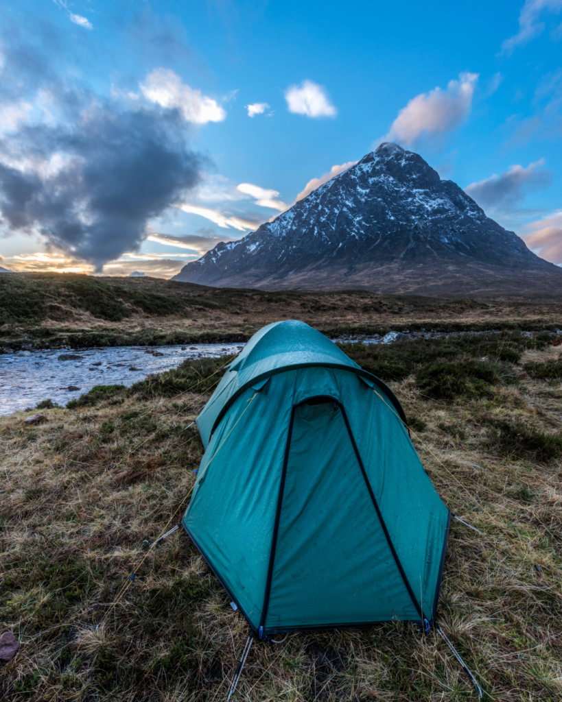
The trail ultimately leads you to the area of the iconic Kingshouse Hotel, situated perfectly to showcase unforgettable views of Buachaille Etive Mòr. This mountain, with its instantly recognisable pyramidal shape, is often cited as the most photographed peak in Scotland. Your pre-arranged overnight accommodation will be secured in this scenic region.
Accommodation Note: Kingshouse Area
Due to the area's remote nature and high demand, accommodation rates near Kingshouse may be variable. Furthermore, securing lodging often requires a transfer supplement if alternative accommodation is necessary. Our team will communicate any supplementary charges related to seasonality or the day of the week to you immediately upon confirming your reservation.
Day 6
Kingshouse to Kinlochleven (9 miles / 14.5 km)
Ascending the Devil's Staircase (Kingshouse Area to Kinlochleven)
Today presents one of the most famous sections of the Way, taking you from the Glencoe valley high up to the trail's highest point before the final descent to Kinlochleven.
History and Ascent
The morning starts on the established track of the old military road, leading you north toward Altnafeadh. This stretch offers magnificent views across the solemn Glencoe Valley—a place of incredible natural beauty and profound historical significance, being the site of the infamous 1692 massacre.
The major challenge of the day is the ascent of the Devil's Staircase. This section, despite its intimidating name, is actually a manageable, zigzag path that climbs sharply to the route's highest elevation point at 548 meters above sea level.
The Highland Highpoint
Reaching the summit rewards your efforts with truly spectacular views. On a clear day, you can look ahead to the towering mass of Ben Nevis, Britain's highest mountain. This viewpoint provides a fantastic perspective across the surrounding rugged peaks.
From this high-altitude pass, the trail begins its long, gentle descent. You follow a winding path that gradually drops you into the deep valley where the small, industrial town of Kinlochleven is nestled by the head of Loch Leven. The arrival here marks the successful completion of a satisfying and varied day of walking.
Day 7
Kinlochleven to Fort William (15 miles / 24 km)
The Final Approach to Fort William
The final day of your epic trek delivers dramatic mountain vistas and the profound satisfaction of completing Scotland’s premier long-distance trail.
The Ascent and the Lairig Mòr
The morning begins with a sharp, sustained climb immediately after departing Kinlochleven. This initial effort quickly pays off, however, by providing extensive views back over the village and Loch Leven.
Once you crest the high ground, the route enters the Lairig Mòr (Great Pass), a wonderfully remote and historic valley. You follow this sweeping pass, moving past remnants of abandoned sheilings (old stone shelters) and enjoying a truly isolated atmosphere as you head in the direction of Fort William.
Into Glen Nevis
The trail eventually leads you into a scenic area of managed forest plantations, where you follow a narrow, winding track that guides you down into the vastness of Glen Nevis.
Here, the sight of Ben Nevis, the United Kingdom's highest peak, dominates the view ahead—a massive presence marking your successful journey to the Highlands. You will follow a wide forestry road that descends past the Ben Nevis Visitor Centre.
The Official Finish Line
The very last segment covers approximately two miles along the main Glen Nevis road. Your adventure culminates at the official end point of the West Highland Way, situated on the main street of Fort William. Here, you can celebrate the conclusion of your 96-mile journey through Scotland's heartland.
Onward Travel? Homeward Bound? Or final night stay? Let us plan what you do next.
- Baggage Transfers
- 6 Nights accommodation
- Bespoke Digital Itinerary
Your trip does not include the list below but some are available as additional extras:
- Meals, snacks and drinks (breakfast maybe included in some accommodations)
- Transport to start (Milngavie) and from finish point (Fort William)
- Overnight Accommodation before and after walk
- Additional Nights - If you wish to stay extra nights in one location, we can amend your booking and itinerary.
- Personal Guide

No Details Found
Related Trips
West Highland Way – Your Way
Please login to add your wishlists.Complete the iconic 96 mile (154km) West Highland Way Your Way – Camping or Hotels, over 2 days or 2 weeks – we’ll create the perfect trip for you or your group!
West Highland Way – 8 Days
Please login to add your wishlists.Our most popular trip! Complete the iconic 96 mile (154km) West Highland Way over 7 walking days with 6 nights accommodation, optional final night stay.
West Highland Way – 6 Days
Please login to add your wishlists.Complete the iconic 96 mile (154km) West Highland Way over 6 walking days with 5 nights accommodation, optional final night stay.